

Wildfire Resources in North Carolina
go.ncsu.edu/readext?971018
en Español / em Português
El inglés es el idioma de control de esta página. En la medida en que haya algún conflicto entre la traducción al inglés y la traducción, el inglés prevalece.
Al hacer clic en el enlace de traducción se activa un servicio de traducción gratuito para convertir la página al español. Al igual que con cualquier traducción por Internet, la conversión no es sensible al contexto y puede que no traduzca el texto en su significado original. NC State Extension no garantiza la exactitud del texto traducido. Por favor, tenga en cuenta que algunas aplicaciones y/o servicios pueden no funcionar como se espera cuando se traducen.
Português
Inglês é o idioma de controle desta página. Na medida que haja algum conflito entre o texto original em Inglês e a tradução, o Inglês prevalece.
Ao clicar no link de tradução, um serviço gratuito de tradução será ativado para converter a página para o Português. Como em qualquer tradução pela internet, a conversão não é sensivel ao contexto e pode não ocorrer a tradução para o significado orginal. O serviço de Extensão da Carolina do Norte (NC State Extension) não garante a exatidão do texto traduzido. Por favor, observe que algumas funções ou serviços podem não funcionar como esperado após a tradução.
English
English is the controlling language of this page. To the extent there is any conflict between the English text and the translation, English controls.
Clicking on the translation link activates a free translation service to convert the page to Spanish. As with any Internet translation, the conversion is not context-sensitive and may not translate the text to its original meaning. NC State Extension does not guarantee the accuracy of the translated text. Please note that some applications and/or services may not function as expected when translated.
Collapse ▲By: Elliot Nauert and Jennifer Fawcett, NC State Extension Associates
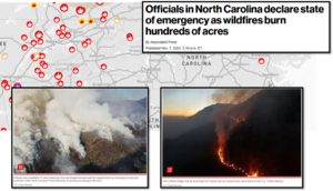
Figure 1: A collection of news media related to wildfires in western North Carolina, November 2023.
At the time of publishing this post on November 21, 2023, North Carolina is finally receiving some much-needed rain to end a dry spell that had the unfortunate timing to coincide with the seasonal leaf fall in the mountains. Those dry leaves acted as fuel for wildfires and over the past few weeks wildfires have burned thousands of acres in the mountains like the Poplar Drive Fire which destroyed multiple homes in Henderson County, and the Collett Ridge Fire which has burned over 5,500 acres. The high fire activity and high fire risk prompted burn bans, public land closures, and a declaration of a state of emergency by state officials (Figure 1).
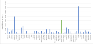
Figure 2: A bar graph showing the number of wildfires for each state in 2022. North Carolina, highlighted in green, had the third highest number of fires for the year.
Although the current rain will be an enormous boost to efforts to control these fires and will greatly reduce near-term fire risk, we should use this moment as a reminder to make sure we are prepared for the next time we face dangerous wildfire conditions. It’s often surprising for many folks to hear that North Carolina experiences some of the greatest number of wildfires in the country as compared to other states (Figure 2). Coupled with the fact that we also have the most wildland urban interface in the country (resistwildfirenc.org), wildfire risk is an important issue for our state.
There are many resources available regarding wildfire in our state that can help you keep informed of current wildfire conditions, learn about wildfire, and take action to reduce your wildfire risk. These include, but are not limited to, the following:
- The North Carolina Forest Service is one of the main authorities for wildfire suppression in the state. Their Fire Control and Prevention page provides links to resources related to fire in North Carolina. There you can find information about how the NC Forest Service manages wildfires, current wildfire activity in the state, how to stay safe in the face of wildfires, and prescribed fire.
- When there are wildfires in your area, you can keep track of them with this interactive map of reported wildfires across the state. It provides information on the wildfire size, location, percent contained, and more.
- Knowing the wildfire danger rating can help you decide what actions you need to take to prevent and prepare for wildfires in your area. This map allows you to monitor the Current Wildfire Danger Rating in your area.
- Many of us live in the wildland urban interface, where fires that burn in the wildland can spread into our communities and impact our homes. Resist Wildfire NC has resources to learn the actions you can take to reduce wildfire risk around your home. You can also check out the FireWise USA® program for educational resources and tips for keeping your home, neighborhood, and family safe from fire.
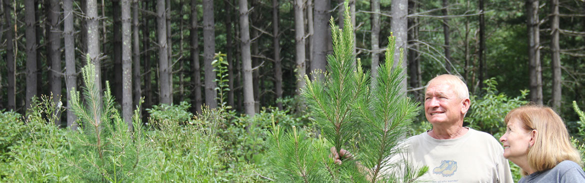
- You can reduce your home’s wildfire risk by landscaping with fire resistant plants and materials so that an encroaching fire is less likely to spread to your house. NC State Extension has a great publication about Fire Resistant Landscaping in North Carolina.
- Ready NC lists important actions to take before, during, and after a wildfire affects your area.
- Even if your home isn’t within reach of the flames, wildfire smoke can still threaten your health from long distances. You can monitor the air quality impacts from smoke in your area using the AirNow Fire and Smoke Map. It provides information like current air quality for your location, the locations of fires and smoke plumes, smoke forecasts, and recommended actions to take to protect yourself from smoke. These recommendations were developed by EPA scientists who are experts in air quality and health.